
We continue to see scary headlines about home insurance companies using aerial imagery to assess home roofs and the surround property. In our view, these fears are mostly overblown click-bait on a slow news day.
Back when I started doing insurance, it was far more common for the local insurance agent to drive over to your property and take photos to send to the underwriters. Aerial imagery has mostly changed that.
Insurers pay special attention to roofs, and they do this because older, worn roofs tend to have more claims. And they also pay attention to the area surrounding your property. Aerial imagery can identify important differences in risks.
Although requirements do vary some from company to company, all home insurance companies are interested in assessing risk and trying to rate appropriately for each risk. Accordingly, they try to identify predictable causes of claims like that tree hanging over your roof and try to rate appropriately for the risks they do see.
This is because claims create expenses that their existing customers will share through the premiums they pay. Some properties with predictably risks may be ruled out, and for most, the idea is for customers with lower risks to have lower prices and those with higher risks to have higher prices.
How is aerial imagery used?
It’s helpful to think back a bit ago, before aerial imagery and AI. How did it work before?
Under the older approach, either your agent or a third-party inspector would come out and take photos of your property. Then, the insurer used those photos to evaluate the risk.
Under the new approach, many companies have added aerial imagery as another tool for evaluating the risk. And they’ve trained software to automatically identify the signs of a deteriorated roof or a cluttered property. (This is a similar approach to what some states like Oregon are using to scan and update areas for wildfire tracking.)
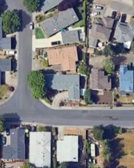
Take a look at this aerial image of five homes in Hillsboro. Which homes would you want to insure? Which might you have concerns about?
The aerial imagery doesn’t tell you everything, but it does tell you some important things. These are all good properties but look how different the risks are.

Note- The insurers use similar aerial imagery (though not Google maps) for underwriting.
The home in the top right has trees overhanging the roof. That’s a risk the other homes don’t have, especially in a storm. The home in the lower left has a pool. That’s a liability risk the others don’t have. The home in the upper left has a deck and the insurance company may want to know if it needs railings around it (trip-and-fall hazard). In sum, insurance companies will take facts like those into account when deciding whether to insure and how much to charge.
An insurer may use the imagery to refuse an offer of home insurance right away. For instance, here in Oregon if the imagery shows moss buildup or big trees hanging over much of the roof, the company may automatically decide they don’t want to insure the house.
Or they may use the imagery to ask for further property inspection. For example, they may see some deterioration but really can’t tell without an onsite visit. In this case, they’ll usually send an inspector or request updated photos from the client or agency.
Now, from the vantage point of the insurance company, using aerial imagery in combination with AI reduces the number of people needed to evaluate roofs and the potential number of claims. Overall, this allows them to find predictable risks, making a marginal profit and keeping home insurance rates competitive.
That last one is the important one to homeowners. We want better home rates and this new tech helps insurers do something they’ve always done, evaluate homes more efficiently. That is one way to help keep prices down.
Aerial imagery and AI are limited tools
But we did say it is mostly overblown click-bait. Why only mostly?
Because there can be some frustrating situations for consumers (and agents!) when imagery and AI gets it wrong.
For example, I’ve seen where the simple pattern of a roof only 12 years old led a company to inspect the house when really it was just the pattern of the roof by design. I’ve also seen a system request an onsite inspection on a 3-year old home in Hillsboro South, a brand-new development!
So the aerial imagery systems are certainly not perfect, but then again, neither were agents or third-party inspectors. (I’ve seen on-site inspectors get the number of floors and ceiling height wrong!)
Along those lines, there do need to continue to be important safeguards in place.
One example of a good safeguard is that when insurance companies non-renew or cancel coverage they are required to provide notice a certain number of days ahead of time. This is important because it gives homeowners time to find new insurance. And there may be other ways of strengthening consumer protections in response to the new technologies.
Also, we’d suggest that good insurers should work to maintain a responsive appeal process. Sometimes the software gets it wrong–sometimes AI is as dumb as a box of rocks– and agents and consumers need a line for appeal.
There does remain an important cultural and political discussion about privacy. Perhaps similar to a car insurance company checking your driving record for car insurance rates. Even so, there’s more good thinking to be done in this area. . . . In the case of a roof and the property, the imagery is directly related to the insurability of the home at a time when someone either has or is asking to insure a house worth hundreds of thousands. Seems reasonable.
Overall, even as aerial imagery will occasionally cause some headaches, we’re okay that companies are seeking more efficient ways to assess risks. The reality remains that if your roof is a reasonable age and you take care of your roof and property, you’ll be able to find insurance.
Related post: “Roof Redone? Notify Your Insurer”
Learn more About Us (actual people!) and our Sensible Approach to insurance.
Go here to request home insurance quotes from us.